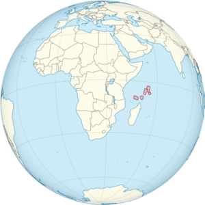
The Seychelles is an archipelago of 115 islands located in the Indian Ocean, lying between 480km and 1600km from the east coast of Africa. The granite and coral islands stretch from 4° to 10° South of the Equator, occupying a land area of 455km², having an Exclusive Economic Zone of approximately 1.4 million km².

Of the 115 islands, 42 are granitic and 73 coral, with most of the islands being small and uninhabited. The island of Mahé is the largest inhabited island and is the main island of the Seychelles where the capital, Victoria, is located.
The islands are also sub-divided into Inner and Outer Islands. The mostly granite Inner Islands are home to 99% of the Seychelles population, most living on the three main islands of Mahé, Praslin and La Digue. The Inner Islands account for about 54% of Seychelles altogether. The Outer Islands make up approximately 46% of the Seychelles and include the Southern Coral Islands, the Alphonse Group, the Aldabra Group, Amirantes and the Farquhar Group.
To the south of Seychelles lie Madagascar, Mauritius, Comoros and Reunion. Seychelles is the smallest of all of these.
The Seychelles is in the UTC+4 time zone, making it 4 hours ahead of UK time in the winter and 3 hours ahead in the summer.
Choose one of the options below to learn more about Seychelles –
| Cookie | Duration | Description |
|---|---|---|
| cookielawinfo-checkbox-analytics | 11 months | This cookie is set by GDPR Cookie Consent plugin. The cookie is used to store the user consent for the cookies in the category "Analytics". |
| cookielawinfo-checkbox-functional | 11 months | The cookie is set by GDPR cookie consent to record the user consent for the cookies in the category "Functional". |
| cookielawinfo-checkbox-necessary | 11 months | This cookie is set by GDPR Cookie Consent plugin. The cookies is used to store the user consent for the cookies in the category "Necessary". |
| cookielawinfo-checkbox-others | 11 months | This cookie is set by GDPR Cookie Consent plugin. The cookie is used to store the user consent for the cookies in the category "Other. |
| cookielawinfo-checkbox-performance | 11 months | This cookie is set by GDPR Cookie Consent plugin. The cookie is used to store the user consent for the cookies in the category "Performance". |
| viewed_cookie_policy | 11 months | The cookie is set by the GDPR Cookie Consent plugin and is used to store whether or not user has consented to the use of cookies. It does not store any personal data. |